 sales@uslandgrid.com
 Phone : 877-870-8872
Transforming Hard Copy Maps into Digital GIS Solutions
Embarking on a digitization effort for your paper-based maps? Have a ton of map pages that need scanned and georeferenced? Need to capture all the associated attributes?
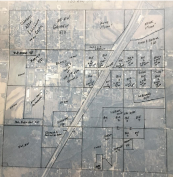
Digitization stands as a proven cornerstone in GIS projects, ensuring efficient data storage and accessibility. This process involves capturing coordinates, transforming maps, drawings, schematics, and other vital documents into precise digital formats. While traditionally time-consuming and costly, the conversion of hard copies or scanned materials, along with satellite or aerial imagery, into vector data unveils a wealth of opportunities for analysis and utilization. From zoning to topography, cadastral to utility mapping, our digitization services cater to diverse needs, ensuring seamless integration and enhanced functionality for your projects on USLandGrid.com
This is where it all began for us. Starting from our Land Grid Product, our roots have always been based in GIS map digitization. With a staff of over 20 long-term employees who focus just on digitization, we have been helping companies and counties across the country with their digitization needs since 2012.
At USLandGrid.com, we specialize in transforming a variety of essential documents, including maps, drawings, schematics, and circuit diagrams, into precise digital renditions through our top-notch digitization services. Moreover, we cater to the digitization needs of zonal maps, contour maps, cadastral maps, topographical maps, and utility maps, ensuring comprehensive support for all your mapping requirements.
We are experts when it comes to ownership polygons and recorded field assets. USLandGrid takes the scanned pages and digitizes based on those pages and the supplied attributes. Where relevant, we adjust to imagery the final delivery of the digitized product.
Our focus areas include:
- Digitizing hard copy parcel maps by rectifying and recording the associated into GIS data.
- Converting hard copy PDF files into digital data.
- Curating and adding to current datasets to improve process and workflows.
Over the last 2 years we have helped counties and parishes across the country convert over 100,000 polygons from hard-copy maps into digital map data that anyone can use and see.
Our Digitization services include:
- Scanning and Georectifying the hard copies.
- Digitizing the lines, points, and/or polygons.
- Inputting and joining the relevant attributes.
Need Help?
Questions about our data or packages?