The store will not work correctly when cookies are disabled.
  • # sales@uslandgrid.com
  • # Phone : 877-870-8872
  • My Account
  • Checkout
  • News
  • Knowledge Base
  • Log In
Toggle Nav USLandGrid - Explore the Unexplored

Migrating your land grid system?

learn more
Search
HOME
DATA
LAND GRID
TAX PARCELS
INFRASTRUCTURE
OIL & GAS
FREE
WEST
Alaska
Arizona
California
Colorado
Idaho
Montana
Nevada
New Mexico
Oregon
Utah
Washington
Wyoming
MIDWEST
Illinois
Indiana
Iowa
Kansas
Michigan
Minnesota
Missouri
Nebraska
North Dakota
Ohio
South Dakota
Wisconsin
SOUTH
Alabama
Arkansas
Florida
Georgia
Kentucky
Louisiana
Mississippi
Oklahoma
Tennessee
Texas
CANADA
Alberta
Manitoba
Saskatchewan
WEST
Alaska
Arizona
California
Guam
Hawaii
Idaho
Montana
Nevada
New Mexico
Oregon
Utah
Washington
Wyoming
MIDWEST
Illinois
Indiana
Iowa
Kansas
Michigan
Minnesota
Missouri
Nebraska
North Dakota
Ohio
South Dakota
Wisconsin
SOUTH
Alabama
Arkansas
Florida
Georgia
Kentucky
Louisiana
Mississippi
North Carolina
Oklahoma
Puerto Rico
South Carolina
Tennessee
Texas
Virginia
NORTHEAST
Connecticut
Delaware
District of Columbia
Maine
Maryland
Massachusetts
New Hampshire
New Jersey
New York
Pennsylvania
Rhode Island
Vermont
West Virginia
WEST
Alaska
Arizona
California
Hawaii
Idaho
Montana
New Mexico
Nevada
Oregon
Utah
Washington
Wyoming
MIDWEST
Illinois
Indiana
Iowa
Kansas
Michigan
Minnesota
Missouri
Nebraska
North Dakota
Ohio
South Dakota
Wisconsin
SOUTH
Alabama
Arkansas
Florida
Georgia
Kentucky
Louisiana
Mississippi
North Carolina
Oklahoma
South Carolina
Tennessee
Texas
Virginia
West Virginia
NORTHEAST
Connecticut
Delaware
District of Columbia
Maine
Maryland
Massachusetts
New Hampshire
New Jersey
New York
Pennsylvania
Rhode Island
Vermont
West Virginia

Our oil and gas data includes well headers, formation tops, completion data, survey data, initial IPs, core data, casing information, perforations and monthly production. Multiple formats are available.

MIDWEST
Kansas
New Mexico
SOUTH
Oklahoma
Texas

Our free data includes boundary files like county boundaries, Texas Rail Road Commission boundaries, nationwide contours and state geology files. Free to download and use as you need.

BASINS

BOUNDARIES

CONTOURS

GEOLOGY

INDUSTRIES

Made for Industry


Discover top-tier GIS solutions tailored to your industry. 

ENERGY
UTILITIES
TELECOMS
FINANCE
FORESTRY
RAIL
MINING
SOLUTIONS

All our data, together, in an easily searchable platform.

Our solutions provide the most updated information with immediate access.

LAND GRID DATA
OWNERSHIP DATA
INFRASTRUCTURE DATA
WELL DATA
MAP PORTAL
DIGITIZATION

Our services include the basics of GIS mapping, to helping countless counties and organizations digitize hard copy maps and documents.

DIGITIZATION
HELP
SUPPORT
Coverage
Data Dictionaries
Data Migration
Datums and Formats
Videos
Terms of Use
ABOUT US
Brochures
Community
Partners
Team
Contact Us
CONTACT US

CONTACT US


 600 17th Street, Suite 2800S, CO 80202

 support@uslandgrid.com

 (877) 870-8872


OPENING HOURS


Mon - Fri: 8am - 5pm MST
Sat - Sun:
 Closed

MAPVERSE New!

Immediate access with all the formats for third party applications.

mapverse_small
My Cart
menu btn
×
  • Home
  • US Land Grid
  • US Wells
  • US Culture
  • US Parcels
  • USStreaming
  • Sample Data
Account

News

  • Home
  • News
Categories
  • News (40)
    • Well Logs (3)
    • Tax Parcels (22)
    • Oil and Gas Data (10)
    • Land Grid (25)
    • Cultural Data (6)
Recent Posts
When Disaster Strikes
October 20, 2025
2025 Tax Parcel Database Mid Year Review
July 24, 2025
Unlock Texas Land Secrets
July 10, 2025
Guide to Land Parcel Data
February 07, 2025
Customized GIS Data
Customized GIS Data
December 19, 2024
Archive
October 2025
July 2025
February 2025
December 2024
October 2024
August 2024
July 2024
June 2024
May 2024
April 2024
March 2024
June 2023
May 2023
May 2022
March 2022
July 2021
June 2021
September 2020
August 2020
August 2019
June 2019
May 2019
April 2019
December 2018
November 2018
April 2018
December 2017
November 2017
September 2017
March 2017
January 2017
November 2016
Tags
tax parcel data landgrid gis data land data tax parcels land grid gis land grid data tax parcel section township range land parcels gis services esri land ownership well logs texas parcel data plss well data aapg land maps open source web mapping tax parcel dataset community rugby sponsors oil and gas wells solar culture equality digitization digitize hard copy customized gis wind streaming legal boundaries log files texas survey map data updated annual convention custom gis oklahoma oil and gas data oil and gas space ice Infrastructure enterprise
  1. News Land Grid

    The Sauce is in the Source

    Anthony Ford - May 21, 2024

    At USLandGrid, we understand that the foundation of accurate and reliable land data lies in the source. That’s why we pride ourselves on providing the most precise, up-to-date, and detailed land grid data available. Our commitment to excellence drives us to always refer back to the original sources, ensuring that our clients receive the highest quality information.

    land_grid_home
    Read more
  2. News Land Grid

    How Many Acres in a Section of Land

    Anthony Ford - May 13, 2024

    Acres and sections are both units of measurement used to determine the area of land. In the matter of land measurements, understanding the relationship between acres and sections is imperative. In this blog post, we will explore how many acres are in a section of land and how to convert between these units of measurement.

    field-371413_1280
    Read more
  3. News Tax Parcels Cultural Data

    Infrastructure Data

    Anthony Ford - April 16, 2024

    Infrastructure mapping isn't just about tracing lines and plotting points on a map. It's a fundamental group of layers that shapes the planning, building, and maintenance of the spaces we live in. It "bridges" the gap between theoretical planning and real world execution, ensuring developments are sustainable, efficient, and aligned with human and environmental needs.

    You can now dive into a world of detail with our extensive infrastructure information, encompassing everything from roads, rivers and bridges to transmission lines, pipelines, wind turbines, power plants, and boundaries. Our data doesn't just skim the surface; it provides a deep dive into the geographical tapestry of your location.

    Read more
  4. News Tax Parcels

    Tax Parcels Matched with Building Footprints

    Anthony Ford - April 10, 2024

    Explore the most complex and detailed tax parcel dataset paired with 135 million+ building footprints. Data that includes the building polygon, the primary occupancy, the parcel of land it resides on, address, height of the building and area of the building - all matched with the most up-to-date tax parcels available. 

    Read more
  5. News Tax Parcels Land Grid

    Land Survey Dispute?

    Anthony Ford - March 25, 2024

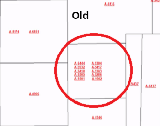
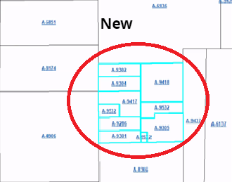
    Imagine facing a costly dispute due to conflicting land surveys. It's a high-stakes situation many in the oil and gas sector dread. In any land asset-driven industry, discrepancies between different land surveys can lead to significant conflicts and delays. One of our clients faced this exact problem, with two opposing surveys (one based on metes and bounds and the other from an apparent survey marker) casting doubt on the boundaries of their operational field.

    DALL%C2%B7E-2024-03-25-08.42.49---oil-and-gas-operators
    Read more
  6. Tax Parcels Land Grid

    The Power of Land Maps in Business Operations

    Anthony Ford - March 20, 2024

    In the ever-evolving oil and gas industry, staying ahead means leveraging every tool at your disposal. Among these, land maps and land ownership data stand out as game changers, offering a wealth of information that can lead to improved strategic decisions and operational efficiencies. This article sheds light on how these resources can be pivotal in navigating the complexities of the oil and gas sector, helping companies optimize their exploration and production activities while minimizing risks and legal hurdles.

    The Power of Land Maps in Oil and Gas Operations

    Understanding the Terrain: Land maps provide crucial geographical information, enabling companies to assess the terrain, identify access routes, and plan infrastructure development with precision. This is invaluable in minimizing environmental impacts and ensuring the safety of operations.

    Strategic Exploration: By combining land maps with geological data, companies

    Read more
  7. News Land Grid

    Land Grid Version 10.0 Released

    Anthony Ford - March 07, 2024
    Abstract_Old
    Abstract_New
    Read more
  8. News Tax Parcels Land Grid

    Tax Parcels

    Anthony Ford - June 21, 2023
    Post_5

    Tax Parcel Data

    It's been a big year when it comes to tax parcels. Our coverage has now expanded to over 3,200 counties, with less than 50 counties remaining to have 100% complete nationwide coverage.


    Most of our parcels are updated more than twice per year and contain over 26 property attributes with property boundaries including

    Read more
  9. News Tax Parcels Land Grid Cultural Data

    The Power of Land Data: Unlocking the Potential

    Anthony Ford - May 15, 2023
    USLandGrid_Most_out_of_your_data

    The Power of Land Data: Unlocking the Potential with USLandGrid

    In the world of maps, real estate, land developers, urban planners, utilities, and even government agencies, having access to accurate and up-to-date land data is essential for making informed decisions. Fortunately, USLandGrid provides a comprehensive solution by offering a wealth of information

    Read more
  10. Tax Parcels Land Grid

    Land Parcels and Location Data

    Anthony Ford - May 23, 2022
    Parcel_Coverage

    150+ million parcel boundaries and growing with over 98% of coverage for the US population.

    Parcels are broken into legal boundaries within the land grid. These land parcels have associated owners, uses and assessments. Essentially, these polygons or land parcels encompass everything from commercial buildings, to homes, parks, farms, and everything in-between.

    Read more
Page
  • Page Previous
  • Page 1
  • You're currently reading page 2
  • Page 3
  • Page 4
  • Page Next

Support

  • Check Order Status
  • Contact Us
  • Customer Information
  • Knowledge Base
  • Migrating Land Grid Systems
  • Order History
  • Videos

Information

  • About Us
  • Brochures
  • Coverage
  • News
  • Partners
  • Our Team
  • Terms of Use

Contact

  • Address: 600 17th Street, Suite 2800 South, Denver, Colorado 80202
  • Email: sales@uslandgrid.com
  • Phone: 877-870-8872

Subscribe

To automatically receive information about our GIS data news and recommended GIS workflows

  • |Search Terms|
  • Advanced Search |
  • Orders and Returns |
Cookie Notice
This website uses cookies to ensure you get the best user experience.
Accept Close More information
Cookie Settings